
Bolivia
Indigenous peoples, Inca Ruins, and llamas
Due to losing the War of the Pacific (1879-1884) with Chile, Bolivia is the other landlocked country in South America (Paraguay too). The nation is made up of 3 distinct geographical regions: the Andes, the Amazon, and the Chaco. These regions vary in temperature, rainfall, and biodiversity, but they all have a common rainy season from about November to March. The Andes are high, cool, and dry. The Amazon is hot and humid. The Chaco is hot and dry. In the Amazon region, lizard is a special protein on the menu that's surprisingly good. Moving through the Andes, you will see llamas grazing, and they are on the menu as well (tastes great). At Lake Titicaca, trout is abundant and prepared in many different ways. However, chicken appears to be the most popular meat in the country. Potatoes, especially boiled, fried chips, and/or the Bolivian chuño style came with every meal.
Post trip thoughts: Bolivian culture is distinctly different from the more European feeling Uruguay, Argentina, and Paraguay. The Indigenous peoples, especially in the Andes, seem to have preserved their language, cuisine, textiles, religion, and other cultural aspects even after centuries of former Spanish colonization. This is no doubt partly due to the logistical difficulties posed by the sheer size/height of the Andean Mountains. The geography and climate in Bolivia were also different. High altitude in the Andes means harder breathing, cooler temperatures, and increased exposure to UV rays. Oddly enough, it was the first place on my trip where I needed sunglasses and sunscreen. Finally, signs of economic difficulties were long lines of trucks at gas stations due to a fuel shortage and the existence of 2 exchange rates: 1 = official; 2 = the real market rate on the street.
Quick facts: Source: CIA World Factbook
Area: smaller than California + Texas
Population: 12.5 million
Ethnic groups: Mestizo (mixed White and Indigenous ancestry) 68%, Indigenous 20%, White 5%, Cholo/Chola 2%, African descent 1%, other 1%, unspecified 3%
Religion: Roman Catholic 65%, Protestant 19.6%, other 4.8%, none 6.1%, etc.
Capital: La Paz (administrative) and Sucre (legislative and judicial)
GDP Per Capita: $9,800
Currency: Boliviano: Official ($1 = 6.9); Blue Market Rate ($1 = 14)

Painting from Saint Teresa Museum and Convent: Potosi, Bolivia
Bolivia

Trip Summary
Date: October 16 - November 2 (Flight from La Paz, Bolivia to Cusco, Peru)
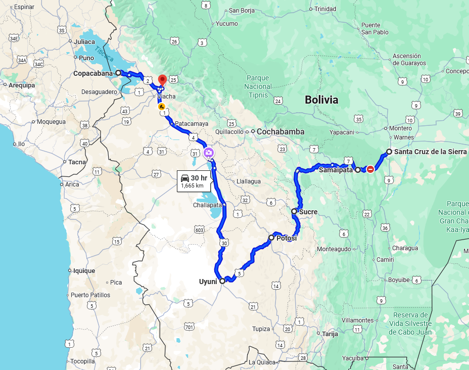
Map Source: Google Maps
Route: Santa Cruz de le Sierra > Samaipata > Sucre > Potosi > Uyuni > Copacabana > Isla del Sol > La Paz
Samaipata
This small, relaxing town of 4 thousand residents is a great first stop away from Bolivia's largest city, Santa Cruz de la Sierra. Besides being a relaxing place nestled in a mountain valley, there's a lot to explore outside of the city as well. While there, I was able to see the pre-Columbian fort "Fuerte de Samaipata" and the animal refuge south of town. According to UNESCO "The archaeological site of Samaipata consists of two parts: the hill with its many carvings, believed to have been the ceremonial centre of the old town (14th–16th centuries), and the area to the south of the hill, which formed the administrative and residential district. The huge sculptured rock, dominating the town below, is a unique testimony to pre-Hispanic traditions and beliefs, and has no parallel anywhere in the Americas." The animal refuge is definitely a place children would enjoy since it's out in the sticks and not in an urban area like a normal zoo. Also, there is a special open area where visitors can interact with: parrots, a peacock, a wild pig, rabbits, and some miniature deer. The deer and wild pig were especially friendly.


Sucre
This city is one of 2 capital cities in Bolivia. Sucre is the constitutional capital and where the judiciary, Supreme Court, is located. The capital city we usually think of is La Paz (the administrative and legislative center). Basically, the buildings surrounding the main square in Sucre are truly impressive and well maintained. One such building is the Casa de la Libertad (Freedom House), which is an interesting former church and museum where Bolivia signed its declaration of independence in 1825.
Only a few miles outside of the city are 2 massive mansions that are also fairly well maintained or restored (Glorieta Castle and Florida Mansion). Both are a must see. First, the Glorieta Castle (built in the late 19th century by a countess who wanted a fairy tale style castle following European travels) is a giant palace and hodgepodge of different architectural styles. It has 3 distinct towers: a chapel clock tower, Arabic style tower, and the tallest is a minaret with stairs to an observation deck that reminds me of a lighthouse. It was totally neglected after being incorporated into a small military facility. Today, it has been separated from the military base, turned into a museum, and the main rooms on the first floor are well preserved. The first floor ceilings are especially detailed and eye catching. However, the upstairs rooms are mostly simple and bare. You can climb to the top of the highest tower and lookout across the region. Finally, the collection of images found inside the dwelling, and displayed in the carriage room, was really fascinating as well.
The 2nd mansion is more traditional in its design and simplicity. The Palacio de la Florida (Florida Mansion), residence of former president Aniceto Arce, might be less complex architecturally than Glorieta Castle, but it definitely feels larger. It's so massive, I was unable to take a picture that encompassed the whole building, and I even got lost for a second trying to find the stairs back down to the first floor. A few rooms still contain the original wallpaper/paintings, and there is a guide to explain certain details of the property. For me, the most surprising part of the tour was when the guide opened a small, 2' x 2', rusty metal door in the middle of the walking area between the palace and outdoor changing rooms. Looking into the small opening, all I could see was an empty, dank room with a dirty floor. According to the guide, this dark subterranean room under the outdoor courtyard was a prison. Unfortunately, this palace also passed between private and public hands leading to a lack of maintenance funds and neglect. Currently, the main functionary rooms look impressive, while other rooms are under restoration or waiting for repair. Both historic mansions are easily reachable by public bus or taxi from Sucre.


Potosi
Spanish Conquistadors scoured the New World looking for gold, but silver was discovered here in 1545. The massive silver deposits on Cerro Rico "Rich Hill" and the surrounding areas would fuel the wealth and expansion of the Spanish Empire for over 2 centuries. Due to the huge amounts of silver being extracted, a massive mint was built in downtown Potosi to turn the local ore into silver coins that would traverse the world. According to the guide at the mint, slave and forced Indigenous labor were both used to do the difficult/dangerous jobs in the mines and the mint. The mining wealth also made its way to the churches, convents, and seminaries that surround the old town. The beautiful churches are still in use while the old convents and seminaries are museums open to the public. Finally, no stop to Potosi would be complete without a mine tour. Although most of the silver deposits were exhausted long ago, other metals like tin, zinc, and lead ares still being pullout out of the hills everyday. For a small fee, $20-30, you can visit an active mine for a few hours. It's a profound and educating experience to see how modern miners exploit the same earth that has been worked for almost 5 hundred years.
The first thing you notice getting of the bus in Potosi is the altitude. At 4,090 meters (13,418 feet), this is one of the highest cities in the world. Just going a few blocks to a supermarket or up a flight of stairs at the hostel felt different and difficult. Even sleeping at night was not easy. It was necessary to consciously breath more and take deeper breadths. The hardest place to breath was definitely in the tunnels on the mining tours. Not only was the altitude in higher in the mine, but I was also wearing a mask to avoid inhaling all the dust in the air. There were times in the mine when I had to stop and take deep breaths to avoid what I feared might become me hyperventilating. Potosi was the highest city I visited in the Andes (Bolivia and Peru), so it was all downhill from here.


Uyuni Salt Flat
Simply, you can drive for 1-2 hours, and it's all salt as far as the eye can see until the mountains rise up in the distance.


Copacabana on Lake Titicaca
The lake is split between Bolivia and Peru. At a height of 3,810 meters (12,500 feet), Lake Titicaca is the world's highest navigable lake. So, you will definitely feel the altitude hiking the hills around town or on the various islands. All I did here is: relax, hike up a tall hill at the end of Copacabana with the Stations of the Cross, take a small ferry boat to Isla del Sol (Sun Island), and eat lake trout prepared in many different ways!


